Spread Simulation #
FLAM › Spread Simulation spreads the burned area from Calculate Burned Area across neighbouring pixels. The result shows where fires burn, not just how much area burns per pixel.
How it works #
- Find fires larger than a pixel. For each day, the tool computes the expected size of a fire in each pixel (
A_burn / P). Pixels where this exceeds the pixel area become fire origins. - Spread those fires. Each fire grows across pixels, driven by that day’s fuel moisture and wind (and wind direction, if you provide it).
- Stop at fuel breaks. Pixels with fuel below the connectivity threshold, or with NoData, act as barriers.
- Keep small fires in place. Fires smaller than a pixel keep their original
A_burnvalue.
Inputs #
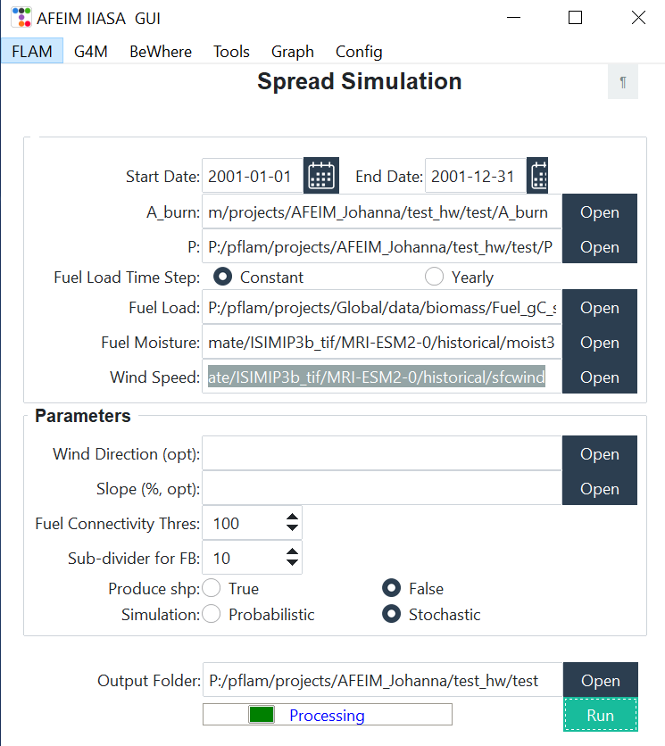
| Field | Description | ¶ fills from |
|---|---|---|
| Start Date, End Date | Simulation period | Config dates |
| A_burn | Daily burned area folder | Results/A_burn |
| P | Daily probability folder | Results/P |
| Fuel Load Time Step | Constant: a single file. Yearly: a folder of *_YYYY.tif files; type the folder path, because the dialog selects files. | — |
| Fuel Load | Fuel load (gC/m²) | Fuel |
| Fuel Moisture | Daily folder | Daily Mois |
| Wind Speed | Daily folder | Daily Wsp |
Parameters #
| Field | Default | Description |
|---|---|---|
| Wind Direction (opt) | — | Daily folder |
| Slope (%, opt) | — | Slope raster in percent |
| Fuel Connectivity Thres | 100 | Minimum fuel load (in the fuel’s unit) for fire to spread. Raise it for dense forest, lower it for sparse vegetation. |
| Sub-divider for FB | 10 | Sub-grid used to rasterise fire shapes. 10 gives 1 % precision; higher values are more precise but slower. |
| Produce shp | False | Also write fire polygons as shapefiles. This is slower. |
| Simulation | Stochastic | Stochastic: ignitions are drawn at random from P, so every run gives a different possible outcome. Probabilistic: every candidate pixel ignites, and results are weighted by P. |
Output #
The tool writes to A_burn_spread/ in the Output Folder:
| File | Content |
|---|---|
A_burn_YYYYMMDD.tif | Daily burned area (km² per pixel). NoData −999. |
A_burn_YYYYMMDD.shp | Fire polygons with prob, date and area (if Produce shp is True) |
pixel_size.tif | Pixel area (km²) |
The run uses all CPU cores but one. The console shows the number of fires left to process.
In AFEIM 1.4.5+pub, the Slope field isn’t passed to the model, so slope has no effect.